

GOES Image Help
How to use the GOES-19 and GOES-18 satellite image viewer: choose an image type, animate, zoom, pan, turn map layers on and off, go full screen and save an image or a loop.
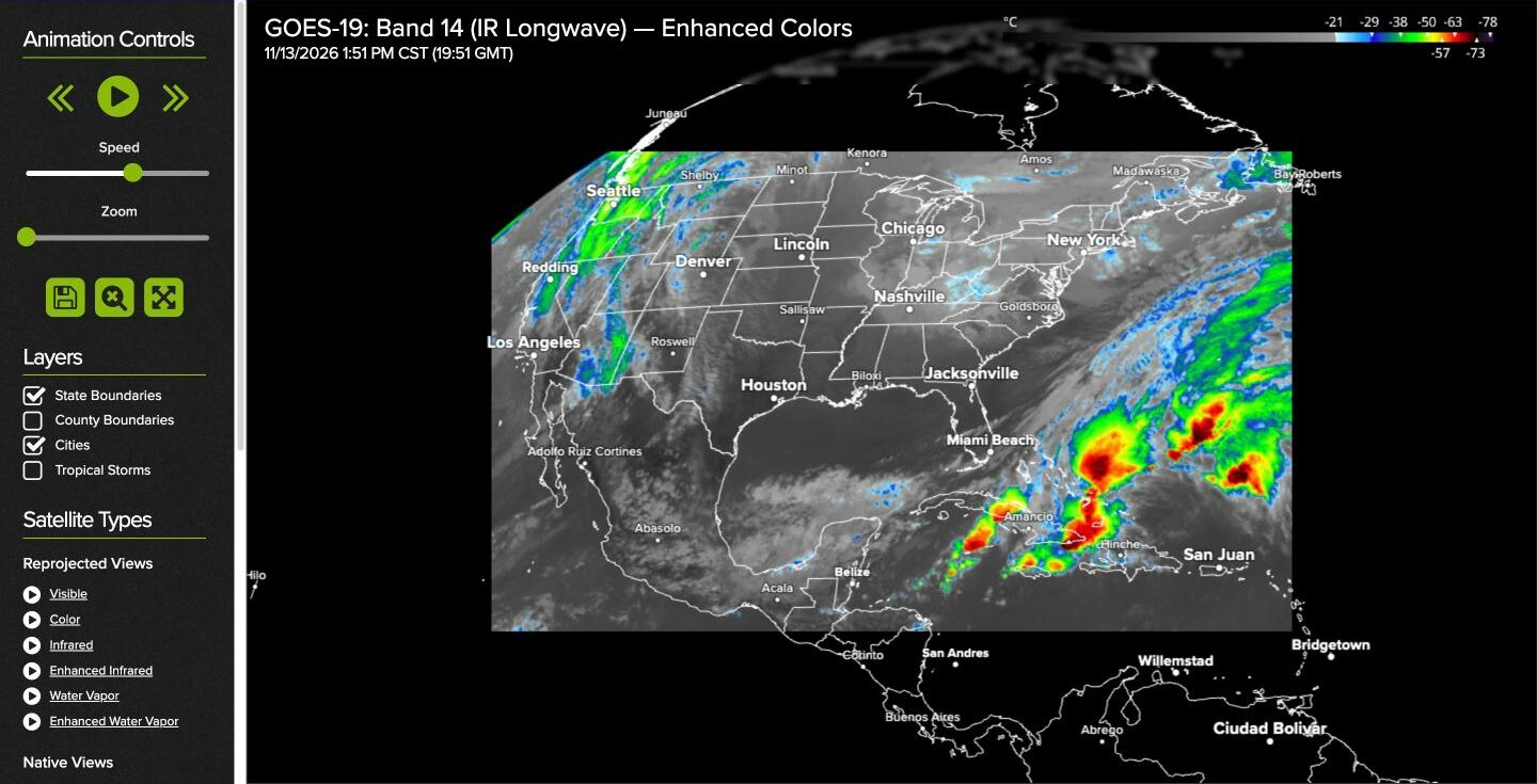
Every GOES image on the satellite page opens in the same viewer. GOES-East views come from GOES-19 and GOES-West views from GOES-18. The image fills the window, and the controls are in the panel on the left. This page goes through them from top to bottom. For what the images themselves show, see the Satellite Tutorial.
| To do this | Do this |
|---|---|
| Play or pause a loop | Click the play button under Animation Controls |
| Step one image back or forward | Click the double arrows on either side of the play button |
| Zoom in or out | Turn the mouse wheel over the image, or drag the Zoom slider |
| Zoom to an area | Hold the right mouse button and drag a box around it |
| Move around | Hold the left mouse button and drag the image |
| Go back to the whole view | Click the cancel zoom button (a magnifying glass with an X) |
| Change the image type | Click a name under Satellite Types |
| Show or hide map lines and labels | Use the checkboxes under Layers |
Choosing an image
The Satellite Types list in the panel switches between the six image types for the view you are on: Visible, Color, Infrared, Enhanced Infrared, Water Vapor and Enhanced Water Vapor. Click a name to show the latest image of that type. Click the small play icon beside a name to open it already animating.
When you change type, the viewer keeps the area and zoom you had. The information panel on the image names the satellite and the band being shown, with the color bar and the time of the image.
Other Images, lower in the panel, jumps to a different sector: the East and West full disks, the East and West CONUS views, the four mesoscale sectors, Alaska and Puerto Rico.
The image refreshes by itself every few minutes, so you can leave a view open and it will stay current.
Animating
Press the play button under Animation Controls to animate the image. The viewer loads the 20 most recent images and then plays them as a loop. Press the button again to pause.
Once the loop has loaded, the double arrows on either side of the play button step through it one image at a time. The time of the image being shown is given on the image.
Drag the Speed slider to the right to make the loop run faster and to the left to slow it down.
You can zoom and pan while the loop is playing. If you zoom in far enough that the viewer needs sharper imagery, it has to load the images again at the new level of detail, which takes a moment.
Zooming
There are three ways to zoom.
Mouse wheel
Roll the mouse wheel forward to zoom in and backward to zoom out. The zoom is centered on the pointer, so put the pointer on the thing you want a closer look at first.
Zoom slider
Drag the Zoom slider under the animation controls to the right to zoom in and to the left to zoom out.
Zoom box
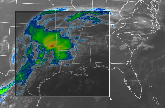
Hold down the right mouse button and drag across the image to draw a box. When you let go, the viewer zooms in to the area inside the box.
Cancel zoom
The middle of the three square buttons below the sliders, a magnifying glass with an X, cancels all zooming and shows the whole view again.
Detail follows the zoom. The wide view uses reduced imagery so that it loads quickly. As you zoom in, the viewer switches to finer imagery, down to 2 km for infrared and water vapor and 0.5 km for visible and color. You may see the image sharpen a moment after you stop zooming.
Panning
Once you have zoomed in, hold down the left mouse button and drag to move the image around.
Layers
The checkboxes under Layers turn map lines and labels on and off. Your choices are remembered for next time.
- State Boundaries
- State and national borders. On the full disk views this layer is called Geopolitical Boundaries. It is on by default.
- County Boundaries
- County lines, most useful once you have zoomed in to a state or smaller.
- Cities
- City names. More cities appear as you zoom in.
- Tropical Storms
- The position, past track and forecast track of active tropical cyclones, drawn over the satellite image.
County Boundaries, Cities and Tropical Storms are offered on the CONUS, mesoscale, Alaska and Puerto Rico views, not on the full disks.
Full screen
The right-hand square button, with four arrows, shows the image full screen with the panel hidden. Press Esc to return.
Saving images
The left-hand square button, with a disk icon, saves a copy of what the viewer is showing, at the zoom and position you have chosen. It asks whether you want a single image or an animation.
- Save Single Image saves the image on screen as a JPEG file.
- Save Animation builds the loop into an animated GIF. This opens a small window that shows the progress. When it has finished, click Save Image in that window. Building a loop takes longer on a large window, so make the browser window smaller first if you want a smaller file.
On a phone or tablet
The mobile site has its own version of the viewer, made for touch.
- Drag with one finger to move the image.
- Pinch to zoom. The image follows your fingers and zooms about the spot between them.
- Double tap to zoom in on a spot.
- Use the play button to animate.
On the mobile viewer the image is drawn in a sharper "HD" mode where the device supports it. Enlarged images keep crisp edges, and the colors of the Enhanced Infrared and Enhanced Water Vapor images stay clean at any zoom. There is nothing to switch on.
If something looks wrong
- Part of the image is black or missing
- The image is made of tiles, and one may have failed to load. The viewer tries again by itself over the next minute or so. If a tile is still missing, reload the page.
- The visible or color image is dark
- Those images need sunlight. It is night over the area you are looking at. Switch to Infrared or Water Vapor.
- A mesoscale sector is not where it was
- The mesoscale sectors are moved by NOAA to follow the weather, sometimes several times a day.
- The right mouse button opens a menu
- The zoom box only works when you start the drag on the image itself.
On this page
Need a hand?
Call (866) 469-9982, Monday through Friday, 8:00 to 4:00 Central, or email support@weathertap.com.