Decoding Guide
Lifted Index Chart
Description:
This chart depicts the two common measures of air stability, the
Lifted
Index and the
K-index.
The lifted index is most often used as an indicator of severe weather, while
the K-index is more closely related to general convection. The more negative
the lifted index the more unstable the air mass is. The higher the K-index
the greater the likelihood of convection.
Issuance:
0000 and 1200 UTC
Data Sources:
Surface and upper air observations, computer models
Discussion:
When clouds and precipitation are forecast or are occurring, the stability
index is used to determine the type of clouds and precipitation. That is,
stratiform clouds and continuous precipitation occur with stable air, while
convective clouds and showery precipitation occur with unstable air.
Stability is also very important when considering the type, extent, and
intensity of aviation weather hazards. For example, a quick estimate of
areas of probable convective turbulence can be made by associating the area
with unstable air. An area of extensive icing would be associated with stratiform
clouds and steady precipitation which are characterized by stable air.
Depiction:
Individual observations are depicted in white. At each station, the lifted
index value is plotted above a symbol and the k-index value is plotted below
the symbol.
Example:
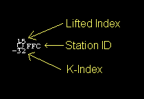
A circle (positive LI) or shaded circle (negative LI) is usually used to
indicate the station location, however, some symbols are used to indicate
missing data.
Symbol interpretation:
 |
Lifted Index Positive (Stable) |
 |
Lifted Index Negative (Unstable) |
 |
All significant observations missing |
 |
Some mandatory observations missing |
 |
Some mandatory and significant observations missing |