
Radar Tutorial
Radar in general
Understanding NEXRAD Operation
Scanning Patterns (VCPs)
Operating Modes
Clear Air Mode
Precipitation Mode
Interpreting weatherTAP Radar Imagery
Reflectivity
Relationship between Reflectivity and Precipitation
Non-Precipitation Echoes and Clutter
Atmospheric Phenomenon
Ground Clutter
False Echoes
Identifying Precipitation
Radar Mosaics
Level II Radar
TDWR Radar
Winter Mask
Additional Sources of Information
The word "Radar" is derived from RAdio Detection And Ranging and refers to the technique of using radio waves to detect the presence and the distance of a target. Radar works by transmitting a radio signal into the air and then listening for a returned signal. If the transmitted radio signal reaches a target, then most of the energy is scattered, but some will be reflected back to the radar receiver. The presence of the target can be confirmed by the reflected signal. Since radio waves travel through air at a known velocity, the distance of the target away from the radar can be determined by measuring the amount of time between the transmission, and the reception of the reflection. Radar was initially designed to detect the presence of aircraft shortly before and during World War II, but today radar is used for a wide array of applications. Since atmospheric moisture will reflect a small amount of radar energy, radar can be used to detect precipitation and other meteorological events.
"Doppler" radar is a special type of radar that makes use of the Doppler Effect to measure not only the distance of a target, but its velocity as well. It works by comparing the frequency of the transmitted signal versus the frequency of the reflected signal. The classic example of the Doppler effect is the sound of a train's whistle as it passes by at high speed. As the train approaches, the pitch (frequency) of the sound will rise until the train passes. After passage, the pitch will seem to be lower. By measuring the change in "pitch" Doppler radar can determine the speed of target. There is one caveat however, the speed is relative to the radar location. For example, if an airplane is flying in a perfect circle around a radar site at the center, the radar would show the speed as 0 because the relative distance between the aircraft and the radar site would be unchanged (there would be no motion relative to the radar site). Using the train example, if an observer was standing in the center of a circle with a train track around the perimeter, the sound of the train's whistle would not change. The relative distance between the observer and the train would always be a constant. If however, the target where flying directly toward (or away from) the radar site, then the measured velocity would be the actual velocity. The velocity component of a target relative to the radar beam is referred to as the "radial velocity".
"NEXRAD" is short for NEXt generation RADar and refers to the nationwide network of Doppler radar sites installed by the National Oceanographic and Atmospheric Administration (NOAA). These sites are specifically designed to provide meteorological data so the official designation is WSR-88D (WSR88D = Weather Surveillance Radar - 1988 - Doppler). The NEXRAD project was started in the late 1980's and was designed to provide comprehensive radar coverage of the United States and to replace older WSR-57 and WSR-74 radar systems. The NEXRAD system is superior to the old ones because it is much more sensitive and allows meteorologists to acquire a much wider range of data. All of the radar images on weatherTAP are produced from data acquired from one or more NEXRAD sites. More detailed information is available on the NEXRAD radar system.
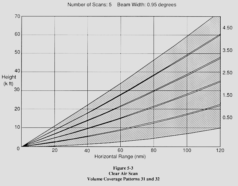
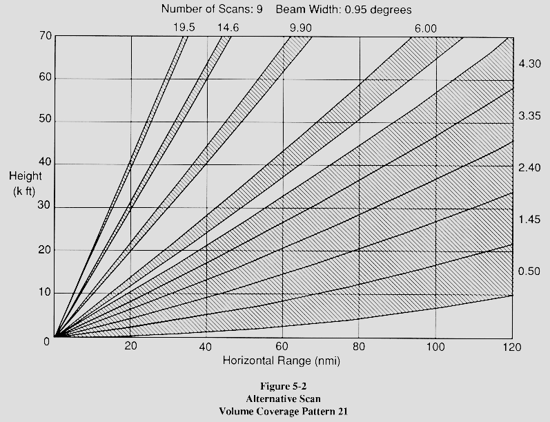
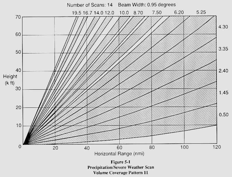
Each NEXRAD site has a 28 ft diameter dish antenna which is used to transmit and receive radio signals. This dish has the capability to rotate 360 degrees in azimuth and up to 20 degrees in elevation allowing the radar to cover a huge volume of atmosphere. The system normally collects data by rotating the dish through 360 degrees at a prescribed elevation. When that scan is completed, the elevation is increased slightly and another scan is performed at the new elevation. This continues until all desired elevations have been scanned. This pre-programmed set of scanning elevations is referred to as the Volume Coverage Patterns (VCP). After the VCP has been completed, the data is processed and images are generated. There are several VCPs that are commonly used. VCP31 is a "Clear Air" pattern and is used when little or no precipitation is detected in the coverage area. This VCP consists of comprehensive scans of five low elevations (0.5,1.5,2.5,3.5, & 4.5 degrees). It takes about 10 minutes to complete this VCP. Another commonly used VCP is VCP21, a "Precipitation" VCP. This VCP consists of 9 elevations starting at 0.5 degrees and ending at 19.5 degrees. This mode allows meteorologists to see a vertical cross-section of a storm and is only used if significant precipitation is detected in the area. VCP21 requires about 6 minutes to complete. VCP12 provides a denser vertical sampling at lower elevation angles which means better vertical definition of storms, improved detection capability of radars impacted by terrain blockage, better rainfall and snowfall estimates, and resulting in more storms being identified. This VCP is completed even quicker with a time to complete of about 4 minutes and 6 seconds. The VCP121 addresses velocity aliasing or the ability of the radar to determine wind velocity and problems caused by "second trip echoes". With the same nine elevation tilts as VCP 21, VCP 121 completes 20 rotations in five minutes. The difference is the radar makes several elevations scans at the same elevation tilt but at different pulse durations (called "pulse repetition frequency" or PRF). Note that although several elevations are scanned, the imagery on weatherTAP is from the lowest (base) elevation. The table below summarizes the VCPs.
| VCP | When Used | Time to Complete | Lowest Elevation |
Highest Elevation |
Number of Elevations |
|---|---|---|---|---|---|
| VCP31 | Clear Air | 10 minutes | 0.5 (base) | 4.5 | 5 |
| VCP32 | Clear Air | 10 minutes | 0.5 (base) | 4.5 | 5 |
| VCP21 | Precipitation | 6 minutes | 0.5 (base) | 19.5 | 9 |
| VCP11 | Severe Weather | 5 minutes | 0.5 (base) | 19.5 | 14 |
| VCP12 | Severe Weather | 4 minutes, 6 seconds | 0.5 (base) | 19.5 | 14 |
| VCP121 | Severe Weather | 5 minutes | 0.5 (base) | 19.5 | 14 |
Each NEXRAD site operates in one of two modes, "Clear Air" mode or "Precipitation" mode.
Clear air mode is the normal mode of operation and is used when there is no significant precipitation in the area. In this mode the radar is VERY sensitive and will detect even minute echoes. Clear air mode utilizes VCP31 or VCP32 and takes about 10 minutes to produce an image. Note that in the winter months, some radar sites will go to Clear Air mode even if there is light snow in the area. The added sensitivity of this mode allows the detection of snow showers since snow generally reflects much less energy than other forms of precipitation.
When the radar detects significant precipitation in the area, it will automatically change to Precipitation mode. This mode is designed to provide higher resolution for relatively strong echoes so the radar becomes less sensitive. It generally utilizes VCP21 and produces an image every 6 minutes. There is also a special type of Precipitation mode sometimes called "Severe Weather" mode. This mode operates like normal precip mode, but utilizes either VCP11, producing an image about every 5 minutes, or VCP12, producing an image about every 4 minutes. These modes are usually only used for research or for extreme weather events like hurricanes or tornadoes.
We are able to obtain useful information from the NEXRAD site by transmitting a radio signal and analyzing any echoes that may be reflected back. "Reflectivity" is the amount of transmitted power returned to the radar receiver and is often designated by the symbol 'z'. Reflectivity is calculated by a complex empirical equation which involves the amount of power received (in Watts), the distance and nature of the target, and other factors. z is in units of mm^6/m^3 and can actually be defined in terms of the density of water droplets which would return a similar amount of power. z covers a wide range of values from very weak to very strong signals, so to produce a more convenient number for calculations and comparison, a decibel scale is often used. Mathematically:
| dBz= 10 * log (z/z0) | Where | z = reflectivity factor |
| and | Z0 is defined to be 1 mm^6/m^3 |
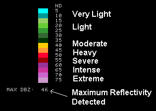
dBz is the symbol used to denote z in decibels and is the units used on weatherTAP radar maps. Note that if z is less than 1 mm^6/m^3, then dBz will actually be negative. This is why Clear Air mode scales go below zero.
NEXRAD radar is very sensitive and can detect reflections as small as -28
dBZ, however, most significant precipitation events will reflect much more
power, usually in the neighborhood of 15dBz or more. In general the more
energy returned to the dish, the more intense the precipitation. WeatherTAP
represents reflectivity by using a color scale plotted on a geographic map.
A legend on the right side of the image shows the relationship between the
colors and the amount of reflected energy. Since Clear Air mode is more
sensitive than Precipitation mode (although over a smaller reflectivity
range), two different scales are utilized.
Clear Air Mode Scale:
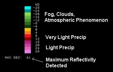
Precipitation Mode Scale:
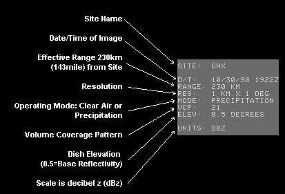
In addition, the header at the top right corner of the image provides additional information about the site.
Sometimes weak echoes will appear on the radar image even though there is no precipitation. These type of echoes are particularly common when the radar site is in the extremely sensitive "Clear Air" mode. There are three general classes of non-precipitation echoes: atmospheric effects, ground clutter, and false echoes.
It is possible (and even likely) that small echoes will be returned even on a clear day. Many things can reflect small amounts of radar energy including clouds, smoke, and fog. Even atmospheric effects like inversion layers and the variation in air density introduced by temperature variation can produce echoes. These echoes are not errors or problems with the radar, they are legitimate metrological, non-precipitation phenomenon detected by the radar. Echoes from atmospheric phenomenon are usually characterized by large uniformly colored areas usually centered around the radar site.
Another class of non-precipitation echo is "ground clutter". These reflections are usually caused by obstacles on the ground, including buildings, mountains, antenna towers, etc. "Ground" clutter does not necessarily have to be ground based. Aircraft, birds, and insects may also clutter a NEXRAD image. Clutter echoes are usually characterized by small points of reflected energy distributed in seemingly random pattern.
The third class of non-precipitation echoes is false echoes. These can occur when variations in air density cause the radar signal to refract (or bend) into the earth. The reflected signal is then refracted back to the dish where it shows up as a very strong echo. This situation is rare, but it has been observed.
The first clue to identifying precipitation is to determine the operating
mode of the radar, Clear air mode or Precipitation mode. If the radar is
in Precipitation mode, then there is a good chance that all of the visible
echoes are indeed precipitation. Examining the strength of the echoes will
not only indicate whether it is precipitation, but also the intensity of
the precipitation (see above). Precipitation usually reflects at least 15
dBz. Precipitation usually occurs in large clumps of activity with strong
echoes in the middle and weaker echoes at the perimeter. Precipitation has
a very characteristic look and is easy to identify with a little practice.
Perhaps the best way to distinguish precipitation from non-precipitation
echoes is to animate the radar image. Precipitation will move whereas most
non-precipitation echoes will be stationary. National, regional, and state radar images on weatherTAP are produced by
compiling data from many NEXRAD sites. All of these products use the Precipitation
mode scale, even if the individual sites are in Clear Air mode. This has
the effect of cleaning up the mosaic and removing most of the non-precipitation
echoes. The images are further enhanced by applying anti-clutter algorithms
to remove non-precipitation data. In the winter months, the algorithms are
adjusted to make the mosaics more sensitive. This is done to detect snow
showers that could otherwise go undetected. Snow generally reflects much
less energy than other forms of precipitation. NEXRAD sites send out two different sets of data. One is called NIDS or Level III and the
other is called Level II data. Radar images created from Level II data have many advantages
over the Level III images. Level II images are shown with 128 colors while the Level III
images are shown with only 15 colors. The much higher number of colors helps provide more
detail of storm intensity. It also allows the ability to locate certain weather
phenomena such as gust fronts and hook echoes that can be hard to see with the Level III data.
The Level II data is available in 0.5 dBZ increments, while the Level III reflectivity data
is only available in 5.0 dBZ increments. This increase in resolution is why many people refer to
Level II radar data has High Definition radar. There are many other difference between Level III and
Level II radar data and the Level II radar data is better in every way. Terminal Doppler Weather Radar (TDWR) is a doppler weather radar system that is located
near major airports and as of 2009, there are 45 such radars across the United
States. One of the advantages of the TDWR radar is that the resolution is nearly twice
that of the NEXRAD radars. This gives much better details on small features in precipitation patterns,
particularly thunderstorms, in the reflectivity and radial velocity. However, this higher resolution
is only available up to 135 km from the radar. Data located beyond 135 km has about the same resolution
of the NEXRAD. One disadvantage of the TDWR is that it uses a shorter 5 cm wavelength instead of the 10 cm
wavelength of the NEXRAD. With the shorter wavelength, the radar cannot "see" very far through
heavy rain and could miss severe weather when there is heavy rain falling between the radar and that storm.
Because of this, it is best to use the TDWR in along with a traditional NEXRAD nearby to make sure that
no storm is missed. Radars are good at determining if there is any precipitation in a given area, but the one thing radars
cannot currently do is determine what type of precipitation is actually occurring. Sophisticated
alogrithms are used to try and determine this. Most algorithms
use current conditions data along with model data to try to determine what form the precipitation is
in when it hits the ground. This is sometimes called a "Winter Mask" and it is applied to a radar image to create
a Winter Radar image. The Winter Radar image will show areas of snow, mixed precipitation and rain. Additional Sources of Information Information on the NEXRAD radar system can be obtained from government publications
or from numerous sites on the world wide web. Details about the NEXRAD radar system can be obtained from the four volumes
of Federal Meteorological Handbook No. 11 (FMH-11). The four volumes and approximate cost are: This handbook can be ordered from the NOAA National Data Centers' Online Store.
A - System Concepts, Responsibilities, and Procedures - $8.00
B - Doppler Radar Theory and Meteorology - $16.00
C - Products and Algorithms - $20.00
D - Unit Description and Operational Analysis - $20.00