
Decoding Guide
Aviation Surface Observations
Description:
This product graphically depicts the latest surface observations from selected stations throughout the U.S.Issuance:
HourlyData Sources:
Surface ObservationsDepiction:
A white wind barb is used to indicate sky coverage, wind speed, and direction. Yellow text next to the barb gives the station identifier, temperature, dew point, pressure, visibility, and the lowest ceiling altitude and coverage.Example:
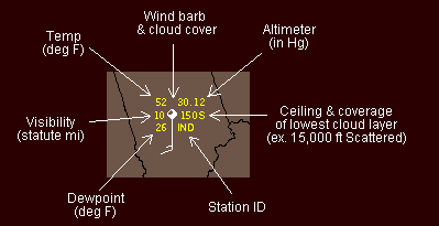
This example depicts a typical late fall observation from Indianapolis, Indiana (IND). The last observation indicates a temperature of 52 degrees and a dew point 26 degrees. Sky is broken with winds out of the South at 15kts (wind barb notation). The current barometric pressure is 30.12 inches of mercury and visibility is 10 statute miles. The "150S" designation immediately to the right of the wind barb indicates both the altitude and coverage density of the LOWEST cloud layer. The first three digits indicate the ceiling altitude in hundreds of feet. The 'S' that immediately follows indicates that the clouds are scattered. Possible values of the coverage density indicator are:
| Abbrev. | Coverage Density |
|---|---|
| CLR | Clear |
| F | Few |
| S | Scattered |
| B | Broken |
| O | Overcast |
Although the "150S" indicates a scattered clouds, the wind barb shows broken coverage. This indicates that a broken layer lies above the scattered layer at 15,000 ft.
(For FAA purposes 'scattered' or 'few' clouds do not constitute a "ceiling", however, the altitude of any reported cloud layer is portrayed on the map regardless.)