Decoding Guide
Extended Weather Depiction Chart
Description:
This product provides a quick overview of sky conditions, ceilings, precipitation and obstructions-to-visibility for selected observation stations. In addition, areas of instrument flight rules (IFR) and marginal visual flight rules (MVFR) are outlined.Issuance:
HourlyData Sources:
Hourly surface observations (human observers and automated stations)Depiction:
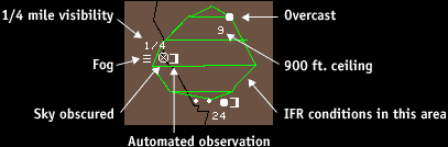
Green shaded Areas indicate IFR conditions. Areas enclosed by a green line, but not shaded, indicate marginal VFR conditions. All other areas are VFR. The number of observations used to generate the report is printed on the left side of the chart.In addition to the green shading, station observations are also plotted on the map in white. Each observation is depicted as follows:
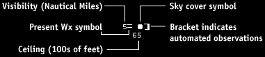
Sky Coverage Symbols
Common Precip and Obstruction Symbols
|
| Continuous Drizzle |
|
| Continuous Rain |
|
| Continuous Snow |
|
| Light fog |
Complete symbol list
Example: